Maps Need Tolls
Last updated on Dec 25, 2025 · 4 minutes
Google Maps (and other maps) need a serious update
Back in September 2008, when Google Maps added turn-by-turn navigation, it was a revolution in everyday trip planning. It saved millions of people billions of hours in route planning and enabled countless others to reach their destination without getting lost. It is not hard to see why Google Maps became the dominant mapping app in smartphones by 2013 – just five years after Google launched turn-by-turn navigation. The world has since moved on. Businesses and customers take it for granted that they will have access to the best mapping engine in the world by integrating Google Directions API, HERE maps routing API, or any other mapping API of their choice. Customers are now dealing with a newer set of problems. In order to solve these problems, mapping companies need to rethink their basic premise of routing. Are travelers always looking for the fastest route to their destinations? Are commuters willing to pay any amount to travel on the fastest route? In short, maps need to mimic how real people make decisions in the real-world.Decisions in a real-world
When was the last time that you boarded a flight without checking the ticket cost? When was the last time that you bought a smartphone without looking at the price tag? But when you decide to drive or when you need to deliver a shipment in your truck, all that you see from the mapping service is the time information. You do not get to see how much it will cost to reach the destination. Now, this is a huge problem. About 60 percent of Americans cannot come up with $1,000 in emergency expenses without getting into debt. Tolls can be expensive, especially when you factor in the violations, late fees, and countless hours spent paying unplanned tolls. Some users pay as much as $3,200 in tolls. But then again: travelers are not necessarily looking to save tolls. Jacob Kleinman writes in lifehackerGreg Garnhart articulates it better in his blog Feature Request: Google Maps PrioritiesEither I want to blacklist certain toll roads (not all) or I want the cheapest fast route (or fastest cheap route) or perhaps a smartly calculated route that minimizes time and cost.
Like get home in 20 minutes for $5 or get home in 40 minutes for $0 or get home in 15 minutes for $18. Or get home in 10 minutes with a $375 reckless driving ticket.
What I want, if Google cares to listen, is a cost-benefit analysis. In other words, I want Google to tell me how much I am paying to shorten my time on the road. If a toll road cuts my commute down by 45 minutes and only costs $2, I may be willing to eat the cost. If I would only save 3 minutes by driving through a $6 gate, you’ll find me in the slow-moving parking lot with everyone else.
A solution: Integrate Toll and Cost API
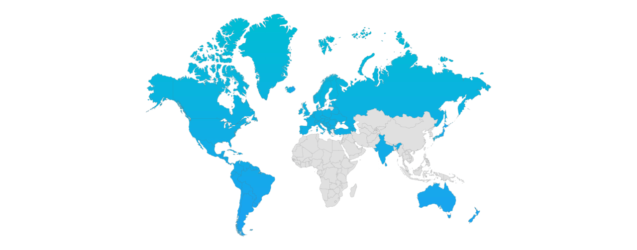
One way for businesses and individuals to get a smart decision platform is by marrying Google Maps (or any other maps) with the TollGuru Toll API. The API service calculates route costs – tolls, fuel expenses, driver charges, and other expenses. Further, it compares the routes by time and cost and ranks routes by the cheapest, the fastest, and compromise routes. Travelers can see the trade-off between time and cost and travel on their optimal route for their trip. Say you need to pick kids from daycare, you are perhaps willing to pay 5 dollars to save 5 minutes in traffic. But if you are going shopping, you may want to sit in traffic and then treat yourself to a Latte. Toll API integration can be a good solution until Google maps and others integrate TollGuru information into their maps Given that the TollGuru Toll API is now available for North America – USA, Canada, Mexico; Europe – UK, France, Spain, Portugal, Ireland, Netherlands, Denmark, Norway, Sweden, Italy, Germany; Russian Federation; Latin America – Peru, Colombia, Argentina, Chile; India and Australia, it can be a good start for mapping companies to add toll information for these countries.


Maneesh Mahlawat
Mapping geek. On a mission to transform maps into a human decision-making platform.
